
Looking back at Sand Dune Arch
(among the fins) from under Broken Arch
This was an easy hike, across a sandy field to a green wash under Broken Arch, then continuing past the arch (which most people don't seem to do), walking under and around sandstone fins to the Devil's Garden campground. This is a small campground (50 sites) and the only one accessible by car (there are other primitive sites in the park but are accessible only by backpacking into them); some of the sites seemed quite nice.

Oh, dear deer!
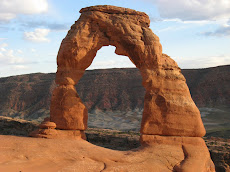
The trail continued through the campground, looping back to Sand Dune Arch (about 2.2 miles total for the loop), and again we had it to ourselves, aside from a rabbit and a couple of mule deer. We popped in on Sand Dune Arch - not really a hike, since it's only about a 200 yard walk in between rocky fins - and then headed into town.

Neck Spring loop
Friday morning, after breakfast and provisioning, we headed up to Canyonlands National Park. We parked at the Neck Spring Loop trailhead at the Shafer Trail overlook; it was early enough that we didn't have to struggle for a parking space. This is a fairly popular spot due to the overlook and we weren't sure how many people we'd see on the hike. The book we were using this time, Best Easy Day Hikes: Canyonlands and Arches by Bill Schneider (he has a bigger book on all the hikes in Canyonlands and Arches that we are going to pick up next), said that it was one of the longer hikes in the book but not difficult by any means.

Neck Spring run-out
We ended up only seeing ten other people - pretty solitudinous for a hike in a national park. The trail alternated between sand and slickrock, taking gradual descents into washes, following the contours of the canyon. Towards the end there was a short, steep climb back to the top of the plateau, and the finish was on slickrock on the mesa.

Climbing back out of the wash
There were lots of springs down in the washes and the extra moisture meant deciduous trees, scores of songbirds and many, many deer and rabbit tracks. There was evidence of 19th century ranchers too: abandoned water troughs and fences. The loop finished out at a viewpoint, looking down at the Shafer Trail. Hike stats: 5.75 miles; 2 hours and 11 minutes of walking, 22 minutes standing around looking at stuff; 1,068 feet elevation.

Abandoned water trough
We ate our lunch at the Aztec Butte trailhead (Aztec Butte is a total misnomer: the native peoples here were ancestral Puebloans) and then decided to climb the buttes to see the ruins. We think we turned back too early on the larger butte, losing the trail to the top on the slickrock, but spent some time admiring the two 1,000+ year old granaries on the smaller butte.

Shafer Trail overlook
The weather started to turn at this point - we could see dark clouds, virga and snow squalls all around us - and we decided to skip the MTBing for the day. It wasn't so dire that we couldn't do another quick walk, however, parking at an unnamed picnic area and walking out to the White Rim overlook. The trail out there was very gentle, with a gradual slope winding its way through gorgeous red sand and juniper glades, and trail's end gave us some of the best views of the White Rim trail that we've ever seen. At which point our camera battery died.

Granaries at Aztec Butte (smaller butte)
The wind picked up as we walked back towards the car, taking a short detour to peek over the edge of the plateau at the nearly-vertical beginning of the Gooseberry Trail (we have since decided that we really, really want to do that trail). We were just two minutes away from being back at the truck when the rain - and hail - started and the temperature quickly dropped twenty degrees. We drove out of the hail as we headed back to town but it was very windy and rainy and we felt pretty smug about not being out on our bikes in the storm.

White Rim trail overlook


No comments:
Post a Comment